“Surveying and mapping have now moved from traditional tape measures and compasses to sophisticated drones and GPS systems”.
– Chris Chambers (Mapping Engineer)
I remember how the traditional compass and tape measures were used for mapping and surveying processes. However, those methods had their limitations and were not suitable for large projects. In modern times, when technology has a better alternative for everything, how could these projects remain last?
Nowadays, most industries have shifted to drones for various related operations, starting from search and rescue to agriculture. And why wouldn’t they, after all, drones are not only fast, and efficient but can also offer accuracy down to 1cm and 0.7cm which can not be expected from any traditional method. (Wingtra: Surveying with Survey Drones)
But how to choose the perfect drone from the numerous options available these days? I know it can be confusing and complicated to find the best-suited device for you. But no need to worry because in this article, I will tell you about the major considerations you need to keep in mind while choosing the drone for your projects.
What’s The Goal Of Your Surveying?
To choose the best-suited drone for your project, your first step should be to identify and get clarity on the goal and objective of your project. Every industry includes different sorts of surveying and requires different devices based on varying their needs.
Many companies trust american-made drones for their projects due to their outstanding quality control, and reliable features. On the flip side, for agricultural surveying, a drone with thermal imaging abilities is preferred to easily spot plant health.
When it comes to construction surveying, it typically relies on a drone that has LiDAR sensors, or first-class cameras, so it can properly capture detailed and sharp pictures of the site.
The point is that it’s up to you to first decide the purpose of your project, so you can proceed with other steps.
FUN FACT Some drones can map up to 200 acres in a single flight, which is significantly faster compared to ground-based surveys.
Moving On To Payload And Durability
Another factor that must be taken into account is the type of payload that you need to carry and the amount of time you need the drone to fly.
For those who are not familiar with these concepts, payload indicates the size and weight of the camera, sensor, and other pieces of equipment that are going to be hooked to this device.
In addition, you can understand durability as the battery life and flight time of the drone. Depending on the mapping goals of your company, you may need to obtain a high-quality camera, a LiDAR scanner, a thermal sensor, or all of these.
What you need to remember is that the different payloads come with different power needs, which can play a significant part in the overall performance of the drone. Also, the terrain and size of the region that you want to map, and the amount of time that’s going to take to finish everything should be taken into consideration.
Generally, if you ask, fixed-wing drones are much more durable compared to other types and are capable of covering bigger areas. However, they are not as flexible and require much more space for landing and takeoff.
On the other hand, multi-rotor drones aren’t as durable and can only cover smaller regions, regardless, they are a lot easier to handle and are capable of landing and hovering in tighter areas.
What’s Your Skill Level?
You will find a variety of drone options available in the market. Some might seem easier to maneuver, while there are those that are pretty complex as far as this is concerned. If you’ve used them before, I would advise you to stick to the brand that you’ve employed in the past.
Why does it matter? Well, think of it like this, if you opt for a brand that you aren’t familiar with, it’s going to take a lot of time to get a grasp of every nuance. Consequently, before you acquire this device, you should first determine your skill level. If you’re new to this game, then Parrot ANAFI USA can be a smart choice for you due to the following features –
Versatile imaging abilities – With thermal imaging, 32x zoom, and a 4k HDR camera, it can adapt to an expansive range of mapping demands, starting from thermal mapping, to site inspection without needing to have extensive technical knowledge and skills.
Advanced flight features – It represents a perfect mixture of portability and endurance, making it an ideal choice for fieldwork in different environments, frequently used by people who have particular knowledge when it comes to drones, and who aspire to further sharpen their skills.
Now, if you have a certain experience as far as this goes, and you think that you can “tackle” something a bit more intricate, then it wouldn’t hurt to consider DJJ Matrice 300 because of the traits below:
Payload capacity – It is able to carry multiple loads, like high-end cameras, LiDAR sensors, and infrared sensors. It’s designed for mapping projects that are quite complex, and that normally require numerous data types.
Extended flight time – With almost fifty-five minutes of flight time, it can collect huge amounts of data over broader regions, decreasing downtime, and, at the same time, boosting efficiency.
Accuracy Is Everything!
What a waste it would be if the outputs you collect from all the surveying and mapping are not accurate. That is why you should only buy a drone that can provide you with the desired accuracy.
A couple of factors that influence it are the onboard sensors’ quality, the drone’s GPS, the altitude at which this device flies, and the type of software that’s being employed.
Drones that come with Post Processing Kinematic and Real-Time Kinematic systems will certainly boost GPS preciseness to centimeter-level precision, which is essential when accuracy and high levels of detail are required.
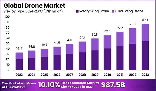
DO YOU KNOW? The global drone market is projected to reach from $36.8 billion in 2024 to $87.5 billion in 2033.
What Type Of Software Do You Need?
The last element that I would suggest you not overlook and keep in mind is the drone’s software. You should figure out what type of software you need to properly control, plan, and process all of your surveying and mapping data.
In these instances, the software indicates the platforms and applications that you employ to create the flight path, supervise the drone’s current status, and analyze the measurements and images.
Depending on your project goals, it would be smart to obtain software that’s able to create ortho mosaics, 3D models, digital elevation models, and other outputs.
As I mentioned in the beginning, there are numerous types of drone technology available, which makes it difficult and confusing to find the right one. But that’s precisely why these tips are here. Everything I shared in this article will help you narrow down your options and pick the one that’s most suitable for your upcoming projects.


